|
|
|
|
|
|
|
|
This is a recommended route to take in all the Kinks locations in Central London, as described on the Jim Smart / Geoff Lewis Big Black Smoke site. Suggestions for improvements would be greatly appreciated. If you are short of time, you may prefer to attempt the Little Central London Kinks Tour. You will need this map and this map. First, buy a London Transport One Day Travelcard from any tube station. (You can buy them in advance of the day you are travelling, if it is more convenient.) This will give you a days unlimited travel on the underground and the red buses. Alternatively, get an Oyster card for economical travel for your entire stay in London. The tour takes 4 - 5 hours and finishes in the Waterloo area, so ideally you should start it at about 5 hours before sunset. (Check here) |
|
|
|
|
|
|
|
|
|
|
 |
|||||||||
|
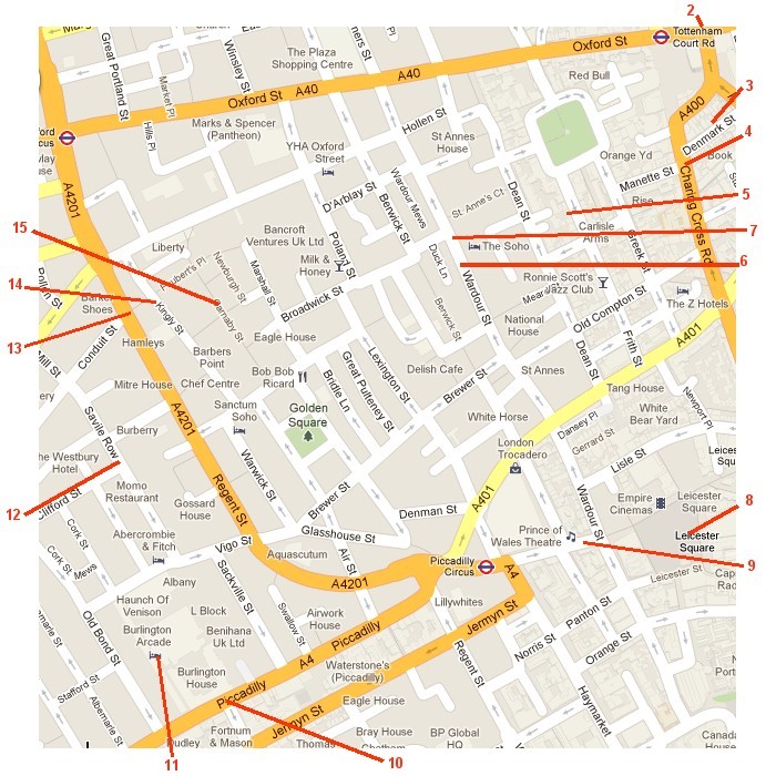
Carry on up Wardour street to number 112, which is now Printroom, but in the 1970s was Henrits Drumstore (7), owned by Bob Henrit. Next door is the Ship Inn, an attractive little pub, which would have been frequented by Bobs customers, who included Keith Moon, Ginger Baker and Michael Charles Avory. (Although according to Bob, Keith was likely to bring a bottle of brandy with him!) It seems only right to have a pint here. |
|||||||||
 |
|||||||||
|
Now walk back down Wardour Street to New Coventry Street and turn left up to Leicester Square (8), where you can either sing Dedicated Follower of Fashion or London Song - or both! |
|||||||||
 |
|||||||||
 |
|||||||||
|
Now walk back down New Coventry Street to Coventry Street. - just past Wardour Street on the right is the Cafe de Paris (9) - you could re-enact the Come Dancing video here. |
|||||||||
 |
|||||||
|
Continue on Coventry Street to Piccadilly Circus, then cross to Piccadilly (10) and sing a bit more of Life On The Road. On the left is Fortnum & Mason, an extraordinarily posh Grocery store. If this was the grocery that Tom the Grocers Boy ended up owning, it is not surprising that Daisy married him! |
|||||||
 |
|||||||
 |
|||||||
|
Here you can partake of an excellent Afternoon Tea, but it isnt cheap and it wont be the same without Donna! Alternatively, you could by a tin of the appropriate blend of tea. |
|||||||
 |
|||||||||||||||
|
Continuing the posh theme, cross over and continue on Piccadilly, then right into Burlington Arcade (11), which featured in Rays story, The Shirt. You can certainly buy some smart - and extremely expensive - clothes here, although the shirtmaker that Ray mentions, Hilditch & Key, is actually in Jermyn Street, just south of Piccadilly. |
|||||||||||||||
 |
|||||||||||||||
|
Turn right into Burlington Gardens, then the 3rd left into Savile Row (12), where you can sing End Of The Season |
|||||||||||||||
 |
|||||||||||||||
|
Turn right into Conduit Street, then left into Regent Street (13) - time to sing a bit more Dedicated Follower Of Fashion |
|||||||||||||||
 |
|||||||||||||||
|
Turn right into Great Marlborough Street, the immediately right into Kingly Street (14), site of the offices of Boscobel Productions. |
|||||||||||||||
 |
|||||||||||||||
|
Turn left into Beak Street, left again into Carnaby Street (15) - time to sing still more Dedicated Follower Of Fashion |
|||||||||||||||
 |
|||||||||||||||
|
Walk up Carnaby Street and left into Great Marlborough Street, then right into Regent Street. At Oxford Circus, turn left into Oxford Street. and catch a number 6, 23 or 159 bus to Edgware Road (the next stop after Marble Arch) Walk up Edgware road and turn right into Seymour Street, You will cross Great Cumberland Place (16), former location of Pye Records. |
|||||||||||||||
 |
|||||||||||||||
|
Turn left into Berkeley Mews (17) and sing the song.
Now walk back along Seymour Street (If you are thirsty, the Carpenters Arms in Seymour Gardens on the right at the corner of Great Cumberland Mews is a nice little pub, which could well have been used by musicians after a recording session at Pye) |
|||||||||||||||
|
|
 |
|||||||||||||||||||||||||
|
From Paddington, take the Circle Line to High Street Kensington, then a number 9 bus to the Royal Albert Hall (19) and sing Session Man |
|||||||||||||||||||||||||
 |
|||||||||||||||||||||||||
|
Walk along Kensington Road, turn left into Hyde Park, then right along Carriage Drive. Rotten Row (20) runs parallel on your left. If you happen to have hunting jackets (and horses), you can attempt to re-create the famous promo photos. |
|||||||||||||||||||||||||
 |
|||||||||||||||||||||||||
|
Now back to Kensington Road and catch a number 11 bus to Sloane Square. You are now in Did Ya country : Go for a walk down the old Kings Road (21). |
|||||||||||||||||||||||||
 |
|||||||||||||||||||||||||
|
Turn right into Cadogan Gardens and continue into Cadogan Square (22). |
|||||||||||||||||||||||||
 |
|||||||||||||||||||||||||
|
Walk back and turn right onto Kings Road. After a short walk, on your left, you will see a McDonalds. This building used to be the famous Chelsea Drugstore (23). It certainly is in a state of ill-repair! |
|||||||||||||||||||||||||
 |
|||||||||||||||||||||||||
|
A little further down Kings Road, you will come to Bywater Street (24) on your right. There is probably nobody home at number 3. |
|||||||||||||||||||||||||
 |
|||||||||||||||||||||||||
|
Now catch a number 11 bus to to The Strand. This bus goes via via Pimlico (25) Road (a bit more Life On The Road) and Victoria (26)Station. |
|||||||||||||||||||||||||
 |
|||||||||||||||||||||||||
|
If you like, you can get off the bus at Victoria and walk to Buckingham Palace (27), in front of which is an excellent monument to Queen Victoria. Sing her song. |
|||||||||||||||||||||||||
 |
|||||||||||||||||||||||||
|
Back on the number 11 and get off at The Strand. Turn right into Savoy Hill - the Savoy Tup, formerly The Savoy Tavern (28), is on your left. Pop in for a pint or two and see if you can spot any characters from Kinks songs here. |
|||||||||||||||||||||||||
 |
|||||||||||||||||||||||||
|
Now back to The Strand, cross the road and bear left into Aldwych, then turn left into Drury Lane. Here you will find the famous Theatre Royal (29). |
|||||||||||||||||||||||||
 |
|||||||||||||||||||||||||
|
Walk back to Aldwych, cross The Strand at the lights and into Lancaster Place, which leads on to Waterloo Bridge (30). Walk across the bridge - you know what you have to sing! |
|||||||||||||||||||||||||
 |
|||||||||||||||||||||||||
|
As you walk across the bridge, look back at Kinks College (31), adjoining Somerset House |
|||||||||||||||||||||||||
|
|
|
|
|
|
Numbers in brackets refer to locations on the GCLKT and LCLKT maps |


